Tsingy de Bemaraha: Madagascar’s Limestone Needle Forest
Tsingy de Bemaraha is one of Madagascar’s most distinctive natural landmarks, known for its vast labyrinth of sharp limestone formations that stretch across rugged terrain in the western part of the island. Recognised as a UNESCO World Heritage Site, this protected landscape combines geological rarity with ecological significance, offering insight into the island’s ancient natural history. The reserve remains a vital refuge for numerous endemic species and stands as a testament to Madagascar’s unique geological evolution.
Geological Formation of the Stone Forest
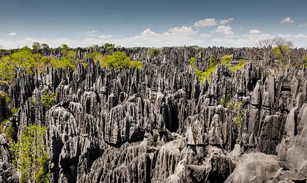
The landscape of Tsingy de Bemaraha began to form over 200 million years ago when layers of marine limestone gradually rose above sea level due to tectonic activity. Over time, the region was shaped by intense erosion caused by wind, rain and groundwater, which slowly carved narrow passages and towering vertical spires. These formations, often referred to as “limestone needles”, reach heights of up to 70 metres, creating a natural stone forest unlike any other.
The erosion process continues today, contributing to the region’s dynamic topography. Deep cracks, sinkholes and underground caves form part of a hidden karst network, much of which remains unexplored due to its difficult and hazardous accessibility. Each section of the reserve presents subtle differences in rock composition and structure, revealing how environmental conditions have shifted across millennia.
Despite appearing harsh and inhospitable, the stone formations support isolated pockets of soil and moisture. These microenvironments have given rise to diverse vegetation adapted to surviving in narrow crevices and sun-exposed surfaces. The reserve’s geological complexity provides a foundation for its equally remarkable biodiversity.
Research and Monitoring of the Karst System
Scientific studies conducted over the past decades have greatly improved understanding of the reserve’s karst system. Specialists in geomorphology, hydrology and ecology work together to map subterranean chambers and identify water flow patterns that influence the region’s stability. Many areas require rope access and advanced climbing techniques, making field research physically demanding.
Recent monitoring has highlighted how seasonal rainfall affects erosion rates and the formation of new fissures. This information is crucial for conservation planning, as increasing temperatures and irregular rainfall linked to climate patterns may accelerate geological changes. Researchers also assess the impact of human activity in surrounding regions to ensure the reserve remains protected from external pressures.
Data collected by field teams is used to develop accurate 3D models that help visualise the evolution of the limestone structures. These models assist both scientists and conservation authorities in predicting long-term geological trends and implementing protective strategies tailored to the reserve’s fragile formations.
Flora and Fauna of Tsingy de Bemaraha
The reserve is home to an exceptional concentration of endemic species, many of which have adapted specifically to the isolated conditions created by the limestone ridges. Forested areas between the rocky pinnacles host rare palm species, dry deciduous trees and specialised shrubs capable of retaining moisture during prolonged dry seasons. Vegetation varies considerably depending on exposure, elevation and soil depth.
Among the most iconic inhabitants are the Decken’s sifaka and the red-fronted brown lemur, both species uniquely suited to navigating vertical rock surfaces. Reptiles are also prominent, with several lizards and geckos found only within the region. Birdlife includes the Madagascar fish eagle, one of the country’s rarest raptors, which relies on remote cliffs and forested waterways for nesting.
The variety of habitats—ranging from forest canopies to shadowed rock crevices—allows species to survive in niches that would be unsuitable elsewhere. Many organisms remain understudied due to the terrain’s complexity, and ongoing surveys continuously reveal new findings about the area’s ecological significance.
Conservation Efforts and Environmental Challenges
Conservation in Tsingy de Bemaraha is managed through a combination of government oversight, UNESCO guidelines and community partnerships. Protection measures aim to limit deforestation in nearby villages, control access to sensitive zones and ensure that the reserve’s unique species remain undisturbed. Rangers conduct routine patrols to monitor wildlife and assess signs of environmental stress.
Climate variations pose increasing challenges. Extended dry periods can affect vegetation and water sources, while occasional heavy rains may trigger structural changes in the limestone formations. Monitoring programmes help evaluate how these shifts influence local ecosystems and guide adaptation strategies.
Local communities play a crucial role in maintaining the reserve’s stability. Initiatives focused on sustainable resource use, education and alternative livelihoods reduce pressure on surrounding forests. Collaboration ensures that conservation aligns with local needs while protecting one of Madagascar’s most distinctive natural environments.
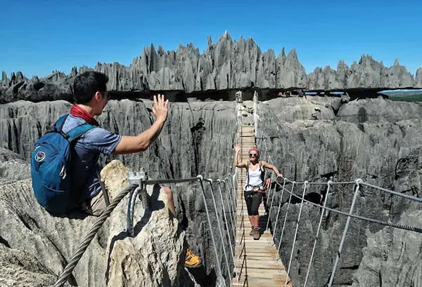
Human Presence and Sustainable Exploration
The region’s human presence extends back centuries, with archaeological evidence indicating that early communities used nearby valleys for seasonal activities. Although the stone forest itself is largely inaccessible, its perimeter has long served as a natural barrier and landmark for travellers and local groups. In modern times, the reserve is carefully managed to balance scientific interest with controlled visitor access.
Infrastructure in the area is limited due to the rugged landscape. Established routes allow safe passage through certain sections, supported by fixed cables and marked walkways to reduce environmental disturbance. Authorities regularly inspect these pathways to ensure they remain secure and do not interfere with sensitive geological or ecological zones.
Guided visits are overseen by trained specialists who provide context on geology, wildlife and cultural significance. Their expertise ensures that exploration respects the reserve’s fragile structure. Through measured access and clear guidelines, visitors can observe the remarkable features of Tsingy de Bemaraha while contributing to long-term preservation efforts.
Role of Local Communities in Sustainable Management
Residents in neighbouring villages participate actively in conservation programmes. Many work as guides, rangers or support staff, gaining stable employment while helping protect the reserve. Training initiatives emphasise environmental understanding and practical stewardship skills.
Community-led projects promote sustainable practices such as controlled agriculture, responsible firewood collection and habitat restoration. These efforts reduce ecological strain and strengthen the connection between residents and the protected landscape. Engagement encourages long-term commitment to conservation goals.
Collaborative management models demonstrate how local participation can support environmental integrity. By integrating cultural knowledge, practical experience and institutional guidance, communities contribute meaningfully to safeguarding one of Madagascar’s most significant natural landmarks.